
NASA Gulf Oil Spill Data
Airborne instruments study the 2010 Deepwater Horizon Gulf of Mexico oil spill.Why is NASA doing this?
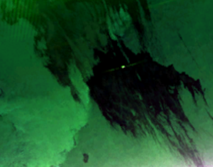 Oil slick in a UAVSAR PolSAR image
The goals of the Gulf Oil Spill Campaign included:
- characterizing oil in the slick in open waters
- tracking oil ingress into coastal waterways and marshlands
- monitoring impact and recovery of oil-affected wetlands
- understanding how the instrument could support emergency responders in future disasters
NASA is still committed to these science goals, supporting yearly science flights over areas along the Louisiana and Mississippi coast to monitor impact and recovery of wetlands most heavily affected by the Deepwater Horizon spill. Pre-spill data over parts of the impacted area were acquired in 2009 and early 2010, extensive data were acquired in June 2010 during the spill, and post-spill repeat track data were acquired in June 2011 and are planned for July 2012.
UAVSAR imaged the Gulf coastline from the Florida Keys to Corpus Christi, Texas, and collected data over several areas of open ocean throughout the Gulf. Scientists will use the coastal data in several ways:
- to study how L-band radars can track the extent that oil from such spills intrudes into coastal and wetland environments
- to assess the impact of oil on different types of vegetation
- to monitor how ecosystems recover after oil has impacted an area
The UAVSAR data will be combined with data collected from other remote sensing instruments, such as the JPL-built and managed AVIRIS optical/infrared instrument, to gain complementary and more comprehensive information about the oil spill and its long-term effects on Gulf ecosystems.
What is UAVSAR?
 The UAVSAR radar pod is attached to the bottom of a Gulfstream-III jet
For more information about radar polarimetry, see this tutorial. The radar will eventually be flown aboard an uninhabited, remote-piloted aircraft such as the Northrop Grumman Global Hawk. The radar was built at the Jet Propulsion Laboratory (JPL) with funding by NASA's Earth Science Technology Office. UAVSAR is managed and operated by JPL under contract with NASA's Science Mission Directorate, Washington, D.C.
What is AVIRIS?
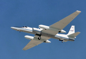 AVIRIS has flown on four aircraft platforms, including the ER-2 jet
AVIRIS has been flown on four aircraft platforms: NASA's ER-2 jet, Twin Otter International's turboprop, Scaled Composites' Proteus, and NASA's WB-57. The ER-2 flies at approximately 20 km above sea level, at about 730 km/hr. The Twin Otter aircraft flies at 4km above ground level at 130km/hr. AVIRIS has flown North America, Europe, portions of South America, and Argentina.